


NOAA Smart Buoys

Description of NOAA Smart Buoys
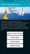
NOAA Smart Buoys is an application developed by the National Oceanic and Atmospheric Administration (NOAA) that provides users with access to real-time weather and water data collected from the Chesapeake Bay. This app is beneficial for individuals interested in environmental monitoring, boating, and recreational activities in the bay area. Users can download NOAA Smart Buoys on the Android platform to stay updated on local conditions and enhance their understanding of the Chesapeake Bay ecosystem.
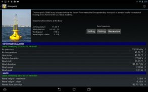
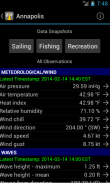
The app's primary function is to transmit data gathered by the Chesapeake Bay Interpretive Buoy System (CBIBS), which consists of a network of buoys stationed throughout the bay. These buoys are equipped with advanced sensors that monitor various environmental parameters, such as water temperature, salinity, and wind speed. By accessing this information, users can make informed decisions regarding their outdoor activities or academic research.
A standout feature of NOAA Smart Buoys is its user-friendly interface, which allows for easy navigation through the data provided. Users can view current weather conditions, including air temperature, wind direction, and wave height, all displayed in a clear and accessible format. The app also offers historical data, enabling users to analyze past conditions and trends over time. This feature is particularly useful for researchers and environmentalists studying the bay's ecosystem.
Another significant aspect of the app is its real-time alerts and notifications. Users can set up personalized alerts for specific conditions, such as high winds or temperature fluctuations. This functionality ensures that users receive timely information that can impact their safety and planning, especially for those engaged in boating or fishing activities. The ability to receive immediate updates helps enhance the overall safety of users on the water.
NOAA Smart Buoys also includes a mapping feature that allows users to visualize the location of each buoy within the Chesapeake Bay. This mapping function provides context for the data being collected, enabling users to see which areas of the bay are being monitored and how the conditions may vary from one location to another. This geographical representation of data is valuable for both recreational users and professionals conducting environmental assessments.
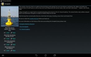
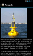
In addition to weather and water data, the app offers educational resources about the Chesapeake Bay and its ecosystems. Users can access information about local wildlife, plant species, and the importance of maintaining a healthy bay environment. This educational component serves to raise awareness and promote responsible stewardship of natural resources among users.
The app is designed to support a variety of users, including recreational boaters, fishermen, educators, and students. Its straightforward design caters to both novice users and those with more advanced knowledge of environmental science. The accessibility of real-time data makes it a practical tool for anyone interested in understanding the dynamics of the Chesapeake Bay.
For users looking to engage more deeply with the data, NOAA Smart Buoys allows for data comparisons across different buoys. This comparative analysis can be particularly insightful for understanding regional variations within the bay. It enables users to identify trends and anomalies in water conditions, which can be essential for both recreational and scientific purposes.
Another feature of the app is its compatibility with other NOAA resources. Users can access additional NOAA tools and information directly through the app, enhancing their overall experience and expanding the data available to them. This integration with broader NOAA services underscores the app's value as a comprehensive resource for weather and environmental data.
The app's design also takes into account various user preferences. Users can customize their dashboard to highlight the most relevant information for their needs, ensuring that they have quick access to the data they value most. This personalization makes the app not only functional but also tailored to individual user requirements.
The NOAA Smart Buoys app is an essential tool for those interested in the health and management of the Chesapeake Bay. Its real-time data, educational resources, and user-friendly features make it a practical application for a wide range of users. Whether for recreational purposes or scientific research, the app provides valuable insights into the environmental conditions of the bay.
In addition to these features, NOAA Smart Buoys encourages users to become more engaged with their local environment. By providing easy access to critical data and educational materials, the app promotes awareness and understanding of the Chesapeake Bay ecosystem. This focus on education and engagement is vital for fostering a community dedicated to the preservation and protection of natural resources.
By utilizing NOAA Smart Buoys, users are empowered to make informed decisions while enjoying the beauty and resources of the Chesapeake Bay. The combination of real-time data, educational content, and user-centric design makes this app a valuable resource for anyone interested in this vital ecosystem.

NOAA Smart Buoys - APK Information
APK Version: 3.0Package: gov.noaa.ncbo.SmartBuoysLatest Version of NOAA Smart Buoys
Other versions


Apps in the same category
 4.094.064.564.45


